
De Bilt is a village east of Utrecht with a population of a little over 10,000. Its name might seem familiar because it is the village after which the famous American Vanderbilt family was named. In Dutch that name simply means “From The Bilt”. In the Netherlands the village is well-known because it is the location of the Dutch National Weather Service. From the heart of De Bilt to the heart of Utrecht it is exactly 5 kilometres (or about 3 miles) and it is a very easy route to cycle. As the video shows you can ride the entire distance in less than 14 minutes, so with an average speed of 21km/h (or 13mph ). The video is 15 minutes. If that is too long for you, you can also watch the 5 minute sped-up version at the end of this post. Some reasons for the high average speed are that all traffic lights outside the built up area are default green for people cycling. And apart from one or two rolling stops there is only one short full stop in the entire route.
Ride from De Bilt to Utrecht in real-time; 5 kilometres in under 14 minutes. Dutch actual speeds may be low, the average speeds are high. Turn on annotations to see remarks to explain what you see. Video has no sound because of the wind noise.

To learn more about how the route evolved into what it is today a little bit of history.
The video starts in the centre of De Bilt in what is now a 30km/h zone. This is possible because in 1937 the route from Utrecht to the east was reconstructed and diverted around the village. On the map above you can see that the new road, now called N237, was constructed with a curve south of the village centre (below the green flag). So the original village main street was already traffic calmed in 1937. In 1985 most motor traffic from Utrecht to the east was further diverted to the motorway A28, which runs even further south. I have shown you a cycle bridge over that motor way in an earlier post. The original route from Utrecht to De Bilt was a narrow tree-lined rural road which even had tram tracks of the intercity tram line to De Bilt and further east to Zeist. Motor traffic, the trams and people cycling and walking all shared the same narrow carriageway.

In 1937 the road from Utrecht to the east was reconstructed and it became a four lane main road. The carriage way was still shared with tram tracks, but on either side of the road there were now so-called service streets. These were to be used by local motor traffic to reach end-destinations on this road and by people cycling and walking. The tram tracks were removed from the carriage way after World War 2, when motor traffic became more important.

Where the road reached the edge of Utrecht a multi-level roundabout was constructed. This roundabout with a top-level for motor-traffic and a lower level for other traffic was finished during World War 2 in 1943. One of my older videos shows this roundabout with some explanation in the annotations.

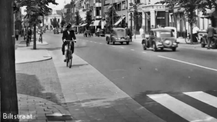
In the municipality of Utrecht the road changes its name from Utrechtseweg or “road to Utrecht” to Biltstraat which means “street to De Bilt”. This street was constructed in the 1100s and paved around the 1290s which makes it one of the oldest paved streets of the country. (Of modern times at least: an earlier civilisation, the Roman Empire, had already constructed paved roads in Utrecht 2000 years ago.) It was part of the main east-west route of the city that I showed other parts of in an earlier post.

An old postcard from around 1900 shows that Biltstraat already had its current width. Only pedestrians had their own part of the streets on the side-walk. Trams, motor traffic, barrows and people cycling all shared the same carriage way.
The big trees didn’t survive the last and very severe winter of World War 2 when the Dutch, especially in the cities, were literally starving. Most of these trees were burnt up for heat. When also the tram service was stopped in the late 1940s this cleared the way for a street reconstruction. It is interesting to see that a separate cycling infrastructure was introduced: cycle lanes with a different surface directly besides the new asphalt carriage way. Five tiles of 30 cm wide so 1.5 metres (almost 5 feet). The street already had bus stop bypasses. This was state of the art street design at the time!

Somewhere between 1950 and 1990 the street was resurfaced and the tiles were taken out. The cycle lanes remained, but a painted line had become the only protection from motor traffic. The lanes were also in the door zone of parked cars.

After 1990 the street was again reconstructed. The main route for cars into the city was diverted. Cars are now supposed to take another motorway exit and enter the city at a completely different location. The main carriage way is now for buses only, because the street has become a designated High Quality Public Transport Route (HOV). This makes it possible for buses to take the most direct and quick route. Private cars have to take a detour. Although the street is still accessible by cars for people who have to be in the area, the street design – partly one-way – is such that it is quicker for through motor traffic to take the detour. For cycling there are now separated cycle ways on the other side of the parked cars. The historic city centre of Utrecht is one big 30km/h zone. This makes separate cycle ways unnecessary there. As can be seen at the end of the video, cycling is the dominant means of transport in the Utrecht city centre. All these measures combined it makes the cycle route from De Bilt to Utrecht fast, attractive, convenient and safe. If you want to go from De Bilt to Utrecht cycling is a very logical transport option to choose.
The sped-up version of the video – also no sound. (This version does not have the annotations the real-time video has.)

Nice video. To me, the transit priority integrated with cycling priority is the most interesting part of this route. It shows what you can do with a constrained space if low-carbon modes get priority.
Very interesting video. I watched the whole 15 mins. We can only dream about cycling infrastructure like that here in the UK
It is horrible that petrol/gas powered mopeds are allowed (and even required) to ride withe the bicycles, as they are more annoying than an average car. However, not too many people seem to use them anyway. Also, the footpaths seem to be a bit narrow. Apart from that – a dream compared to Austria, as in most of those videos.
I hate those mopeds. In parts of Amsterdam, they are a real safety hazard.
I actually don’t find it. The speed differential is not that much between bikes and mopeds. I find more dangerous cars mixed with mopeds.
Where I live in Manchester (UK) there is an old closed railway route which is one of the nicest bits of car-free cycling around.
Because it used to be a railway it has grade separation at every junction so it is similarly continuous and free of interruptions.
The only negatives are that we had to lose the train line (back in 1958) to get this one facility, and that it has artificial barriers at regular intervals to try and stop kids on motorbikes from using it. These barriers make it very hard for bike trailers, bakfiets, tandems, trikes, etc
http://madcyclelanesofmanchester.blogspot.co.uk/2011/04/barriers-to-cycling-on-fallowfield-loop.html
At 8:00 you can see the results of my proposal on behalf of the Fietsersbond. The municipality made two “fietspoolplaatsen” at the side of the bike path for all the school children gathering there around 07:45 in the morning. They were cluttering up this busy junction on the northern branch to De Uithof in rush hours.
Ah thanks! I was wondering what those larger pieces of side-walk were for. Makes a lot of sense.
I had wondered when the trees along Biltstraat disappeared, as I’ve seen the old photos of the tree-lined street. Although I knew about the hard times during/after the war, I never made the connection. Thanks for the history lesson.
Happy New Year Mark,
Altijd fijn je artikelen te lezen! Groet vanuit la douce France. Judith.
Nice vid (as always!) – really shows how great NL intersection design is. Countries like Oz barely regard the intersections, thinking the path is enough.
Really nice to see pals riding side-by-side. Love the cat6 race with the guy with the brown backpack 🙂