For my fifth and last ride in the series “from Market to Market” I cycled to the Markt of Waalwijk. The starting point was again the Markt of ʼs-Hertogenbosch. This ride is 20.8 kilometres long and it took me an hour and two minutes. Again I cycled with an average speed of 20 km/h. In both Waalwijk and ʼs-Hertogenbosch we see a variety of types of Dutch cycling infrastructure, ranging from on-street cycle lanes, cycle streets and service streets to modern bi-directional cycleways, but in the country side it is one very long stretch of a bi-directional cycleway alongside a canal. Ships cannot use this canal. It was dug between 1907 to 1911 for one reason only: to prevent flooding of the city of ʼs-Hertogenbosch. It leads surplus water from south of ʼs-Hertogenbosch to the larger rivers, bypassing the city. Since this canal was dug the city centre of ʼs-Hertogenbosch has never been flooded again. Because of the purpose of the canal it stays well away from places where people live. That means you get to cycle in an area that seems deserted. An exceptional experience in a country that belongs to the most densely populated in the world.
In Waalwijk the route connects to a recent bi-directional cycleway on an old railway line. This one track railway line was used until the 1970s, to get supplies to the leather industry and the shoe making industry in this region. Much of the line – that ran all the way to ʼs-Hertogenbosch – could perhaps be used like this to create a shorter and fast cycle route from Waalwijk to ʼs-Hertogenbosch. Where the railway line runs through a protected nature area nowadays, it could be diverted. It would then serve more residential areas. After which it could connect to the fast cycle route from Vlijmen to ʼs-Hertogenbosch, which already exists for some years. I showed you that route earlier. The distance of this new route would be about 2 kilometres shorter than the route I show you in this post. Since it would pass more residential areas it would be great for all the people living there to be able to reach Waalwijk or ʼs-Hertogenbosch by bike in a faster and more convenient way. There already are cycle paths to reach both cities, but a new route would have a higher quality standard. The new route is still in an early development stage. The municipalities were investigating the possibilities in the first half of 2016. Until that route is finished, one of the many existing alternatives is the route you will see now.
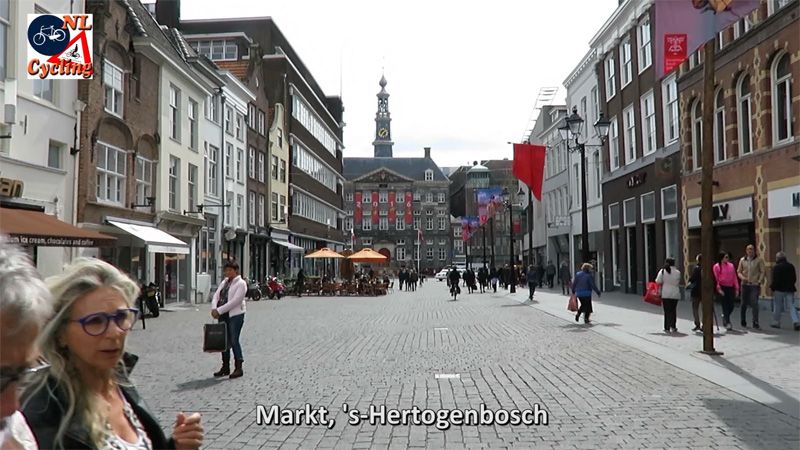
The starting point is at the market square in ʼs-Hertogenbosch. City hall can be seen in the distance. The area of the city has been car free since the 1970s. Cycling has been permitted in this area for a few years now. The clock on the town hall tower shows it is 13:35h.Residents can get a pass to lower the bollards to enter this area with their cars. The driver in the distance at the bollards is most likely to turn right, into the side street. There is a parking place, for residents of this area, in that street.Just outside the 30km/h zone is this street to the station. It is not really used by through traffic and since there is no parking allowed, the wide on-street cycle lanes suffice. Before this street was redesigned in the mid 1990s, there were separate cycle tracks, but that is not really necessary in such a secondary street.This is a service street and at the same time a cycle street. Cycling is allowed in both directions, motor traffic can only use the street in one direction. Because parking is on the left hand side, there is no door-zone cycling. The right hand side is free of obstacles.The cycle street ends and changes into a bi-directional cycleway. That will be the type of infrastructure for most of this ride. Albeit in different widths.This mobility scooter is allowed on the cycleway, because it is considered to be a slow-type moped. (See the regulations in an earlier post.) The width of the cycleway does make that possible and when someone with a handicap uses it, most people aren’t annoyed by these vehicles. There is a tendency, however, that these vehicles are used by people who are not handicapped at all. Especially in Amsterdam that is becoming a problem, on the paths, as well as on the sidewalks, where they are parked and blocking the way for pedestrians.A group of school children was doing a training run. Racing cyclists do wear lycra and helmets.The cycleway runs over this sluice gate. This is the narrowest part of the entire route, but it is only this narrow for a few metres. Note that there is no “cyclists dismount” sign. People have to take turns to cross the sluice. Who has priority is not indicated, but apparently that doesn’t pose problems.The route alongside the canal is interrupted a few times by crossing roads. There is not really much traffic. Adjusting my speed made it possible to cross all those side roads without putting my foot down. Note that there is a warning sign for road works ahead. What that meant becomes clear in the next picture.Wood workers were doing maintenance work on the trees alongside the cycleway. They made sure that there are no overhanging branches in the way for instance. Their truck blocked the entire path. I tried cycling on the grass, but it was too soft. When there was also a branch in the way I couldn’t go further. While I dismounted, someone in the truck shouted to his colleague on the ground to move that branch out-of-the-way for me. Which he did right away. After I passed the truck, I could mount again.At this point the route moves to the other side of the canal. To be able to do that safely and in a convenient way, there is a separate bridge for the cycleway and one for motor traffic.This part of the cycle route is a lot narrower than the earlier parts. It is still easy though, to pass this older man. People do still cycle side by side on such paths. To be able to pass other people they will then cycle single file for a short while. If you approach from behind it is customary to ring your bell once or twice, (not too aggressively) to indicate you would like to pass.To let me pass, this father slowed down a bit, to ride behind his daughter. You can see that the canal is now on the right hand side.This is a bi-directional cycleway that was built on the old levee of a disused railway line. This route may be extended in the direction of ʼs-Hertogenbosch to form a fast cycle route to that city from Waalwijk.There were only three signalised intersections in this entire 20.8km route, all in Waalwijk. The waiting times were 9 seconds, 7 seconds (this picture) and 35 seconds (next picture) respectively. I did not have to put my foot down for any other reasons in the filmed ride (apart from dismounting for the wood workers).The longest wait in this ride was crossing this major road in Waalwijk. It took 35 seconds to finally see this green light.An on-street cycle lane on this 50km/h street in Waalwijk. This is where the street becomes a “school zone”. (You can see that written on the surface, “School zone” in English is also “School zone” in Dutch, but the two are prononced differently.) Even though a sign advises motorists to ‘reduce’ their speed, the school zone was not officially designated as a 30km/h zone.The town centre of Waalwijk has been traffic calmed. In the distance you can see retracting bollards, from there only delivery vehicles can continue. The fast-type moped in the far distance is not allowed to go there, so he uses this street illegally.The final destination, the Markt of Waalwijk with town hall. The clock shows it is 14:50h, but I only cycled 1 hour and 2 minutes. This means I lost 13 minutes for a few reasons. (To change the batteries and the memory card of the camera, and to go back after a wrong turn.)
The picture of the Service street/Cycle street brings to mind a dilemma that is occurring for Central Ave in Los Angeles. Mayor Garcetti started a small project called Great Streets in each of the 15 council districts and Central Ave was chosen to receive treatments for one of those council districts.
Several articles in Streetsblog were written about this.
This Streetsblog article has a diagram with 3 concepts for the street. There is currently four motor vehicle through lanes and curbside vehicle parking on both sides of the street. The sidewalk is 7-feet wide where pedestrians walk and an additional 5 foot wide space next to the curb on the sidewalk where trees, poles, furniture, and signs are located.
The recommended proposal is to remove a through motor vehicle lane in each direction, install a middle turn lane and increase the sidewalk width by 5-feet on each side of the street. That can be seen in the diagram entitled RECOMMENDED “Maximize Pedestrian Space”. Included in that diagram is a picture of a seating area with umbrellas that was installed in a 10-foot wide space in the street on Broadway in downtown LA. That’s probably the inspiration for more pedestrian space on Central Ave. Unfortunately, 5-feet on Central Ave is not enough width to install seating and umbrellas.
The first stage of the Central Ave Great Street project would be to move the parked vehicles 5-feet away from the curb and use temporary materials like paint and plastic posts to designate that space for pedestrians. Building a permanent expansion of the sidewalk using concrete is beyond what will probably occur in the next twenty years. The city doesn’t even have enough money to maintain the current sidewalks and roads which makes the idea of constructing a wider sidewalk out of concrete unrealistic. What’s disappointing to some people who live in that community is that bike lanes will not be installed on the left side of parked vehicles. But when you think about it would placing that space between the parked vehicles and the curb be safer and more attractive for people to ride a bicycle compared to a bike lanes between moving vehicles and parked vehicles? Of that 5-foot width, 18 inches is taken up by a gutter pan where no one is likely to ride a bicycle. There is a possibility that a passenger car door would swing out and hit a bicycle rider, but that’s less likely than getting hit by a driver side door and then by a moving vehicle if that space was used for a bike lane between the parked vehicles and moving vehicles.
I did a bike/pedestrian count on Central Ave last fall for two hours in the evening peak commute time. There were just over 100 bicycle riders. Less than 10 were in the street, the rest were riding on the sidewalk. Installing bike lanes might double the amount of people riding on the street, but the majority would probably still be riding on the sidewalk. A bike lane stripe next to a high volume of fast moving traffic is not persuasive enough to convert many people to riding in the street.
After some further thought I figured out how there could be protected bike lanes installed on Central Ave in Los Angeles. Notice in the Streetsblog article, that I provided a link to above, that one of the diagrams shows a unprotected bike lane to the left of parked vehicles. One of the two through motor vehicle lanes that would be taken away is shown as a center turn lane. There is no great need to have a center turn lane that goes all the way down the center of the street, only at the approach to major intersections is there a need for a left or right turn only lane for motor vehicles. Mid-block that 10-foot wide center turn lane could be used to provide more space for a protected bike lane between parked vehicles and the curb.
Here’s a video made by someone riding along the newest protected bike lane installation in Los Angeles on Los Angeles St. It’s only a half-mile installation in downtown LA that is the first to have bicycle specific signals in Los Angeles and also the first street in Los Angeles to have bus stop islands that are away from the curb. That half-mile installation cost $750,000 to create, or $1.5 million a mile.
A crucial design element that is missing is a barrier between the right-turning vehicles and the bicycle lane at the approach to the intersection. Its against the rules in the U.S. traffic engineering handbooks to put a bike lane to the right of a right-turn only lane for motor vehicles. So what the traffic engineers did on Los Angeles St was move the bike lane to the left of a right-turn only lane for motor vehicles. However, a way around that is to install a concrete barrier between the bicycle lane and the right turning vehicles and install bicycle specific signals and no right turn or left-turn signals for the motor vehicles. I’m describing what is a common way of designing intersections in the Netherlands.
The protected bike lanes on Los Angeles St. is considered a pilot program to test out for are new ways of installing bike lanes for the city of Los Angeles. Why that street was chosen is that it already had buffered bike lanes which provided the needed space and also police cars were being parked in the bike lanes as you can see in the second video from the top in this link below:
Another reason that influenced the decision to choose Los Angeles St for a new design for a protected bike lane is that the downtown area is in the district of by far the most progressive councilmember for active transportation of the 15 councilmembers in the city of LA. He’s the only councilmember that wanted more bike lanes in his district than the new 2035 Mobility Plan provides. One councilmember wanted all the bike lanes shown on the plan in his district to be removed from the plan.
One correction to my comment above. There are plastic posts that keeps the protected bike lane to the right of a right-turn only lane for motor vehicles. That and bicycle specific signals is evidently sufficient enough to claim that there is a barrier to separate the turning vehicles from the bike lane. Not every intersection is done that way. Towards the end of the first video the bike lane is moved to the right of a right-turn only lane.
It’s amazing, how inconvenient the small sections of on-street bicycle lanes appear even on film compared to the rest of your trip.
I have one question regarding the bi-directional bicycle paths next to larger roads: Sometimes these are criticized because in the dark the lights of oncoming cars might have a blinding effect on cyclists using the paths on the “left” side. Is this actually a problem and how do the Dutch deal with it?


The picture of the Service street/Cycle street brings to mind a dilemma that is occurring for Central Ave in Los Angeles. Mayor Garcetti started a small project called Great Streets in each of the 15 council districts and Central Ave was chosen to receive treatments for one of those council districts.
Several articles in Streetsblog were written about this.
This Streetsblog article has a diagram with 3 concepts for the street. There is currently four motor vehicle through lanes and curbside vehicle parking on both sides of the street. The sidewalk is 7-feet wide where pedestrians walk and an additional 5 foot wide space next to the curb on the sidewalk where trees, poles, furniture, and signs are located.
http://la.streetsblog.org/2015/07/09/great-streets-tactical-urbanism-and-the-challenge-of-flipping-the-traditional-planning-process-on-its-head/
The recommended proposal is to remove a through motor vehicle lane in each direction, install a middle turn lane and increase the sidewalk width by 5-feet on each side of the street. That can be seen in the diagram entitled RECOMMENDED “Maximize Pedestrian Space”. Included in that diagram is a picture of a seating area with umbrellas that was installed in a 10-foot wide space in the street on Broadway in downtown LA. That’s probably the inspiration for more pedestrian space on Central Ave. Unfortunately, 5-feet on Central Ave is not enough width to install seating and umbrellas.
The first stage of the Central Ave Great Street project would be to move the parked vehicles 5-feet away from the curb and use temporary materials like paint and plastic posts to designate that space for pedestrians. Building a permanent expansion of the sidewalk using concrete is beyond what will probably occur in the next twenty years. The city doesn’t even have enough money to maintain the current sidewalks and roads which makes the idea of constructing a wider sidewalk out of concrete unrealistic. What’s disappointing to some people who live in that community is that bike lanes will not be installed on the left side of parked vehicles. But when you think about it would placing that space between the parked vehicles and the curb be safer and more attractive for people to ride a bicycle compared to a bike lanes between moving vehicles and parked vehicles? Of that 5-foot width, 18 inches is taken up by a gutter pan where no one is likely to ride a bicycle. There is a possibility that a passenger car door would swing out and hit a bicycle rider, but that’s less likely than getting hit by a driver side door and then by a moving vehicle if that space was used for a bike lane between the parked vehicles and moving vehicles.
I did a bike/pedestrian count on Central Ave last fall for two hours in the evening peak commute time. There were just over 100 bicycle riders. Less than 10 were in the street, the rest were riding on the sidewalk. Installing bike lanes might double the amount of people riding on the street, but the majority would probably still be riding on the sidewalk. A bike lane stripe next to a high volume of fast moving traffic is not persuasive enough to convert many people to riding in the street.
After some further thought I figured out how there could be protected bike lanes installed on Central Ave in Los Angeles. Notice in the Streetsblog article, that I provided a link to above, that one of the diagrams shows a unprotected bike lane to the left of parked vehicles. One of the two through motor vehicle lanes that would be taken away is shown as a center turn lane. There is no great need to have a center turn lane that goes all the way down the center of the street, only at the approach to major intersections is there a need for a left or right turn only lane for motor vehicles. Mid-block that 10-foot wide center turn lane could be used to provide more space for a protected bike lane between parked vehicles and the curb.
Here’s a video made by someone riding along the newest protected bike lane installation in Los Angeles on Los Angeles St. It’s only a half-mile installation in downtown LA that is the first to have bicycle specific signals in Los Angeles and also the first street in Los Angeles to have bus stop islands that are away from the curb. That half-mile installation cost $750,000 to create, or $1.5 million a mile.
A crucial design element that is missing is a barrier between the right-turning vehicles and the bicycle lane at the approach to the intersection. Its against the rules in the U.S. traffic engineering handbooks to put a bike lane to the right of a right-turn only lane for motor vehicles. So what the traffic engineers did on Los Angeles St was move the bike lane to the left of a right-turn only lane for motor vehicles. However, a way around that is to install a concrete barrier between the bicycle lane and the right turning vehicles and install bicycle specific signals and no right turn or left-turn signals for the motor vehicles. I’m describing what is a common way of designing intersections in the Netherlands.
The protected bike lanes on Los Angeles St. is considered a pilot program to test out for are new ways of installing bike lanes for the city of Los Angeles. Why that street was chosen is that it already had buffered bike lanes which provided the needed space and also police cars were being parked in the bike lanes as you can see in the second video from the top in this link below:
http://ciclavalley.org/the-low-down-on-the-los-angeles-st-protected-bike-lane/
Another reason that influenced the decision to choose Los Angeles St for a new design for a protected bike lane is that the downtown area is in the district of by far the most progressive councilmember for active transportation of the 15 councilmembers in the city of LA. He’s the only councilmember that wanted more bike lanes in his district than the new 2035 Mobility Plan provides. One councilmember wanted all the bike lanes shown on the plan in his district to be removed from the plan.
One correction to my comment above. There are plastic posts that keeps the protected bike lane to the right of a right-turn only lane for motor vehicles. That and bicycle specific signals is evidently sufficient enough to claim that there is a barrier to separate the turning vehicles from the bike lane. Not every intersection is done that way. Towards the end of the first video the bike lane is moved to the right of a right-turn only lane.
I meant to say that towards the end of the first video the bike lane is moved to the left of a right-turn only lane
It’s amazing, how inconvenient the small sections of on-street bicycle lanes appear even on film compared to the rest of your trip.
I have one question regarding the bi-directional bicycle paths next to larger roads: Sometimes these are criticized because in the dark the lights of oncoming cars might have a blinding effect on cyclists using the paths on the “left” side. Is this actually a problem and how do the Dutch deal with it?
Reblogged this on nearlydead.