There are usually more routes you can take for the same journey from A to B. In the Netherlands most of those routes will be suitable for cycling. The route from the north of the city to the centre, that I showed you two weeks ago, is a main cycle route. However, between the exact same beginning and end you can also choose an official alternative route. In Dutch it will become a “doorfietsroute” for which I cannot think of a snappy English equivalent. The meaning comes close to a “carry-on cycle route”. Which sounds very strange in English, but in Dutch it has several positive connotations: non-stop, useable at a good speed, without barriers etc. In other words, a good alternative. But the route has not yet been reconstructed to be such a route. So far it is “just another cycle route”. Which means this post is showing you the before situation of a route that will be reconstructed to become a good alternative route.
Detail from the plan to update the route alongside the river Vecht to become a secondary cycle route as a Cycle Street. I enlarged a detail yet again to show some exit constructions and the red asphalt of the cycle street.Utrecht wants to build several alternative convenient cycle routes. This one follows the shore of the river Vecht. It is a very green route and the whole route will be transformed into a cycle street. That means the route will get red asphalt and cycling will get priority. The project is to be finalised between now and 2017. Not much else will change, but this was enough to have residents up in arms. They fear things will change much more than they will actually do. The route already is a main alternative cycle route, as the video will show you. The situation will really only improve, because parking will be done in parking bays, away from the actual road way. The response of the residents shows that even in The Netherlands people get all stressed when something changes to their living environment. People do not like to hear cycling gets priority over motor traffic. Even though in reality all that will change is the colour of the asphalt and the location of the parked cars.
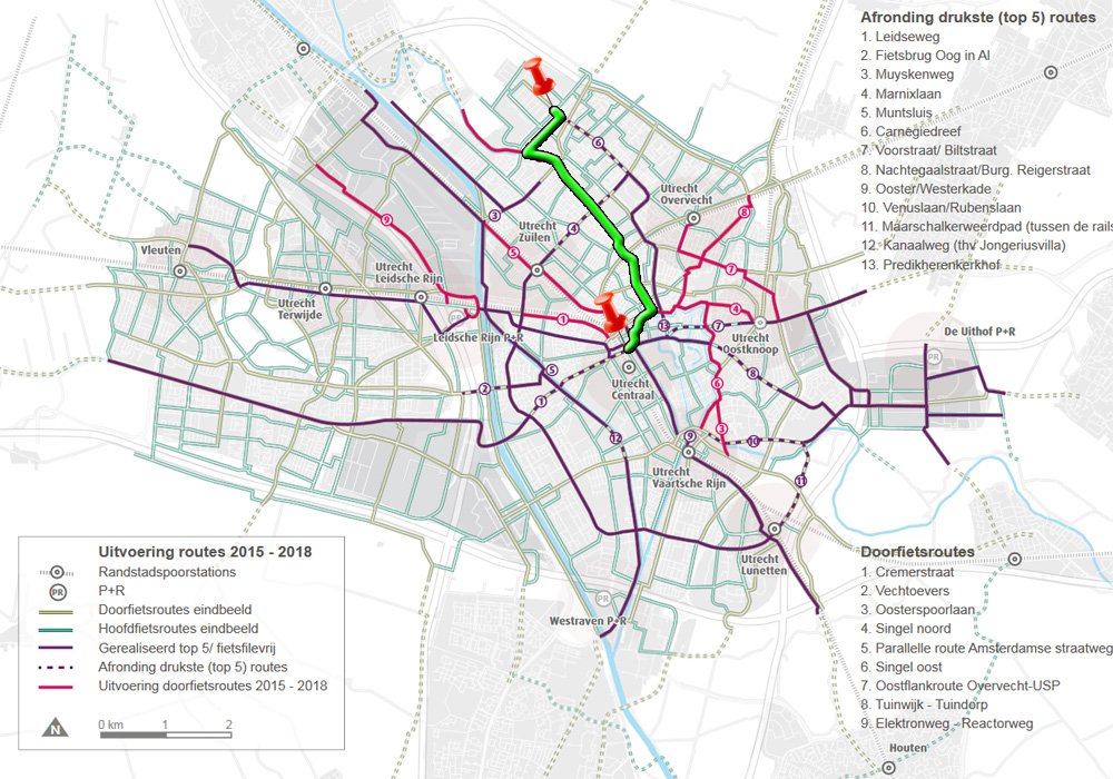
This week’s cycle route in green on the map. I runs from the exact same beginning and ending as two weeks ago, but is a little to the west of it.So let’s see what the route currently looks like.
The beginning of the route is the same as two weeks ago. But in the far distance, just behind the white van I take a right turn this time, where I went straight on last time. Note that the signs have changed. Where this was a combined cycle/moped path the (fast type) mopeds now have to use the roadway. The alternative route is obviously not a main cycle route. The path is much narrower. This is a path next to a canal leading to the river Vecht. This route crosses main car routes 5 times. All those times you have to give priority. Traffic was light though, so it was not such a problem. Two junctions have signals, compared to 9 in the main route I showed you two weeks ago. The only place where you can see that we actually cycle alongside the river Vecht. Most of the time the house boats are so close together that you cannot see the river. The hedges also do not help. This will be smooth red asphalt in future to become a cycle street. It is clear the route is already used by many people on bikes. Two racing cyclists try to pass a group of people here. The first man makes it, the second has to wait for me to pass. He cannot safely overtake the group without being in my way. The road now has quite a number of speed bumps. This older type is also unpleasant for cycling. In the new cycle street there will still be a number of speed bumps but I hope they are of the type that are less annoying for cycling. Zandpad used to be Utrecht’s Red Light District. In the house boats to the right prostitutes presented themselves behind the windows. Traffic here had little interest in people cycling. The eyes of the drivers where mostly somewhere else. That is why there was a protected cycleway here. With all the house boats boarded up, and all traffic of visitors gone, the cycleway has become completely unnecessary. The only time we cross a major road is under the approach ramp of a bridge for that road over the river vecht. That the crossing is grade separated makes this a very convenient and safe crossing. Note that there are two people cycling on the roadway. With all motor traffic gone they feel no need to use the (mandatory) cycle way. They won’t get in trouble because of it. In fact the cycleway will be removed when this route will become a cycle street. This is as far as the customers of the prostitutes were allowed and able to go. They had to turn here. That is why the cycle way ends right after this turning point. For a brief moment the cycle route needs to follow a street away from the river. It is only about 50 metres though. I wonder how this point will be changed, if at all, when this will become part of a secondary cycle route. The left turn followed by a right turn (in both directions of the route) does not feel very convenient, nor safe at the moment. The route continues parallel to the river, but at some greater distance. There are now buildings between the street and the river. The street now has a surface of bricks and is even narrower. That means that if car drivers park wrongly not much space is left. In this case two drivers broke the law and we have to zig-zag between their vehicles. With streets this narrow, every parking movement becomes an obstacle. Besides this one, there was one other parking vehicle that I had to ride around. But in all of the 5 kilometres, of mostly shared space, I actually only had direct interactions with 8 drivers of motor vehicles (one of which was a motor cycle), including all 5 road crossings where I had to give priority. Not counting the two signalised intersections. It makes a lot of difference when there are no parked vehicles. At those places the street suddenly feels wide enough. This is already almost in the city centre. I was very careful with this car. Not only because I saw a foreign license plate. (Foreign drivers are generally not so used to cycling.) In this case the driver was also clearly not looking in front of his vehicle, but talking and looking to the passenger. His speed was also too high and I doubt he realised that cyclists can legally ride against traffic here. Reason enough for me to seek shelter in the empty parking bay and wait untill the driver had passed. He did see me in the end (at about the moment of this picture) and he looked genuinely startled. Here, I arrive at the reconstructed Jacobsstraat. Busy just moments before I had to cross it, but totally clear at my moment of crossing. I showed you the reconstruction of this street in a previous post. Just before I rejoin the main cycle route, I pass the reconstruced old city moat of Utrecht. (Which I showed you in a previous post.) The (newly planted) tree to the right is wrapped in boards to protect it. There are reconstruction works going on in the building on the left hand side. At this location I encountered two signals at a short distance. Taking about 50 seconds of red time in total. The infrastructure at this location is all temporary. It is the busiest place for cycling in the entire city, because several routes come together here. The same end-destination. One of the side entrances to Utrecht’s central railway station. It is currently undergoing a massive reconstruction. It wil take a while before everything is finished at this location.
9 thoughts on “Alternative cycle route in Utrecht”
The “doorfietsroute” follows a slightly different and easier route then you presented above. Where you leave the “Zandpad” and meet the “Rode Brug” you actually cross this bridge over the Vecht and then make a left turn. You then keep following the Vecht on your lefthand side (Lagenoord, Hogenoord, Zeedijk, Bemuurde Weerd Westzijde and (via a right turn) the Weerdsingel Westzijde. This road is much wider for most of the route so cyclists and pedestrians / residents don’t have many conflicts as they do via the route you suggested.
For me, it is unclear what will be the route according to the plans – the map you showed is to abstract to recognise the streets. For the city centre I would make a left turn (Monicabrug and St. Jacobsstraat), for the railway station I would cross Oudenoord and follow the Weerdsingel and Catharijnesingel.
Yes, that is true, that would be the route, crossing Roode Brug, but unfortunately they are building a new neighbourhood on the west side of the river Vecht, which means that the Zeedijk is closed for quite some years. That is why I decided to stay on the east side of the river. The route only goes as far as the old city centre. So how you go from there is up to you. The roads you mention are all main car routes so they have a lot of traffic and signals. That was what I tried to avoid with my route (which is the route the planner of the Cyclists’ Union advises as “shortest route”.)
Hey Mark, do you know how much this new route will cost? I’d be interested if you could do a blog post one day on how much it costs to build different types of bicycle infrastructure in NL.
I grew up near the Hague, but am now living in San Diego, California. They are going to build a 5 km ‘bikeway’ (painted lanes, some ‘mini roundabouts’, speed bumps, and a few protected intersections ) near my apartment here and they are estimating it’ll cost $8.3 million! I feel like for that much back in NL they could have done entirely separated cycletracks (road is 16 m wide!) the whole way, and better intersections. Am I wrong?
Is this the route that is already the LF route coming in from the north (From Breukelen along the Vecht)? I recognise the row of boarded up house boats, I was baffled as to why people do not live there; I thought it was something to do with vandalism or something like that.
Yes, it is.
The protected path along the prostitution zone was highly needed, as cars cued up there most of the day and drivers payed more attention to the windows than the road. Also, as you were riding towards the city center (as in the video) you were inbetween the boats and all those cars. Not a very welcome feeling. I seldom used this route along the Zandpad before the separated bike path was created.
Although all road users there might be “recreational”, the two groups (cars and cyclists) didn’t mingle well. Never saw parked bikes there anyway…
The brick road part of this route indeed is extremely “bricky”. Due to the lack of comfort I have been avoiding this road for the last 15 years. Now the route mentioned as main route two weeks ago has become very attractive. There are at least five different routes possible with some sub-route variations on top of that. Up to some years ago none of these was attractive.
As in more Dutch cities, the more straightforward routes are busy streets with a lot of delay due to narrow cycle paths and traffic lights. The alternatives, through residential areas were seen as alternatives but kept their residential status for road design, no priority at crossings, parking and poor road surface quality (brick roads without any maintenance for tens of years).
The presented main route really is a huge step forward as it shows that it actually is possible to design a contiguous route of high quality from just outside the city center to the outskirts of the city. This can only be done when there is a long term strategy and willingness to create space for cyclists.
In Utrecht the breakthrough only partly is due to left wing parties. The growth of the city, outwards and inwards with filling in empty spaces and redeveloping areas, led to the conclusion that it is impossible to accommodate for ever increasing car usage. This was written down in a rather abstract document “Utrecht aantrekkelijk en bereikbaar” (attractive and accessible). The fundamental step here is to state that a street not only must be seen as a traffic facility but also as living area with its demands as such.
With this in mind you can also improve rather busy roads. And when even arterial roads become more attractive for pedestrians and cyclists, also the living areas away from that road will become more attractive.
Oh yeah, I forgot that cities other than Amsterdam have red light districts (of, roodlichtezoneen). Not going to take advantage of it though. And the fact that this is considered inferior to the Dutch says a lot about cycle route quality standards outside of the Netherlands. It would be considered the shit if it were anywhere else. I hope that you don’t mind that phrase.
Local cycle route as a translation of doorfietsroute is OK. Maybe call it a Dutch style cycle path to anyone who has a clue that there is a lot of cycling in the Netherlands given the connotations with quality and directness (just like who pays the cheque at restaurants and bars). I guess it’s time to get busy with more loanwords. Mind if we borrow (read steal) a word from your language again? I already did so with a bunch of Dutch words like ja, fiets, fietspad, meirenneuker, and hagelslag (ah chocolate sprinkles, the thing that keeps all of the Dutch going on their 25 kilo metal two wheelers each day).
Well, I’ll try to keep “Mierenneukers” as far away from me as possible. Those nasty people don’t fuel by bike riding.