
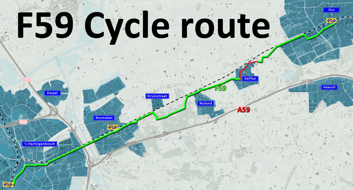
The fast cycle route between ʼs-Hertogenbosch and Oss will be officially opened next month. What is already finished today though, is impressive enough to show you now. The first part of this F59 was already opened in 2014 and – with a delay of one year – the rest has now finally been built as well.


What caused the one-year delay has not become entirely clear to me, but I can take an educated guess. In the now dissolved municipality of Maasdonk, with the two villages Nuland and Geffen, there was fierce opposition to the fast cycle route. The municipality ceased to exist on the 1st of January 2015. Nuland became part of ʼs-Hertogenbosch, while Geffen was added to Oss. Apparently, it took a bit more time than expected to completely incorporate those two villages in the two larger municipalities. It didn’t only take longer in these villages, in Oss the red asphalt also only appeared at the beginning of 2016. The cycleroute in Nuland does now also mostly consist of red asphalt. There is still opposition in Geffen though, and their village main street has so far remained exactly as it has always been. The ‘village council’, an advisory board, still does not want a “route for fast cycling” in their busy village main street. Their spokesperson said: “These fast cyclists should steer clear from the village and take a road to the south of it.” Which makes clear they completely misunderstand what a “fast cycle route” is. Not a (longer) route for fast cyclists, but the shortest route for ‘ordinary’ cycling, with priority and without barriers, to make it a fast route, without actually having to ride fast.


The almost one 1-kilometre unfinished interruption in the Geffen village centre is not so terrible, the route runs through a 30km/h zone there. The 20 kilometres which are finished are very impressive. What struck me is that much of the part that I called finished in my 2014 post has been changed since then! Not only did markings appear – which was very necessary so you can actually find the route – but large parts that had smooth black asphalt were resurfaced to get smooth red asphalt. This also helps to find the way; you can just follow that red carpet for cycling. Other parts were redesigned as Fietsstraat, cycle streets where cars are guest. In ʼs-Hertogenbosch a service street was reconstructed to become such a cycle street. It meant the brick pavers went out and a strip of red asphalt strip was put in. The side streets from the right all had the right of way (the standard priority arrangement in a 30km/h zone), but that priority has been altered. Now the main cycle route has priority over these side streets. The speed humps were removed to increase comfort for cycling. Lastly, the parking lane was moved to the other side of the street. This will prevent possible dooring incidents (even though that risk is always very low in the Netherlands). Other examples of minor and major changes to the route are shown in the pictures with this post and a video with some before and after examples.


The biggest change is not in that video, simply because I didn’t film the before situation. That is how the “Waterleidingstraat” near Nuland has turned out. This used to be a minor country road (60km/h) with protected cycle paths running alongside of it; one-way on either side of the road. But the road has very little motor traffic and the two narrow cycleways would not meet the fast cycle route standards. So to give cycling more space, the entire road is now reconstructed as a Fietsstraat (Cycle street). The motorists that still use the road, now have to share the road with cycling. A grey mountable median in the red asphalt makes that perfectly clear. Drivers overtaking cyclists have to do so in the other lane. Some people were not so happy with this arrangement. They fear motor traffic going too fast will make it dangerous. That is why the municipality of ʼs-Hertogenbosch decided to keep the former mandatory cycleways and to designate them as non-mandatory cycleways now. That way people can choose where they wish to ride. A very unusual arrangement. The Netherlands does not normally create a dual system for cycling infrastructure. But this only proves that there are no rules or regulations cast in concrete when it comes to cycling infrastructure in the Netherlands. The actual infrastructure will always be adapted to the local situation. I used the street several times now and it was encouraging to see that most people did ride on the cycle street and not on the former cycleways. The drivers I met did speed a bit too much, but they also decided to overtake in the other lane. I hope that, after some time to get used to this street, everybody will decide to ride in the street.


The local newspaper stated that the F59 would not officially qualify as a “snelfietsroute” (fast cycle route). They claim this has to do with the number of times that you still have to give way to motor traffic. In the 21-kilometre ride that is 4 times. Two times in Oss and two times in ʼs-Hertogenbosch. A fast cycle route is supposed to mostly have grade-separated crossings. There are also 5 intersections with traffic lights. Two in Oss and three in ʼs-Hertogenbosch, but I lost a mere 46 seconds for the 5 signalised intersections combined! Traffic signals are really friendly to cycling in the Netherlands! I don’t think all these intersections are very problematic. They don’t really slow you down, at least not when I filmed. I did ride faster on this new route, even faster than in the 2014 video. (In the before and after video I had to speed up the before images by 25% to get both images synchronised!) One intersection where the priority was given to cycling now is more problematic in my opinion. The sight lines are bad, so drivers cannot see people cycling approaching. There is foliage in the way. That could and should really be fixed!


With the opening one month away, most of the route was finished and built to a great standard, when I filmed the videos, late July. I hope something will still happen in Geffen. There should at least be some signs, so you can find which way to go, to get from one to the other of the non-connected F59 parts.


Facts and Figures
Total length of the route: 21 km (1 km missing in Geffen in August 2016)
Total costs for the construction: 4.7 m Euro, shared as follows:
Provincial Government of North-Brabant 2.405m Euro
National Dutch Government 1.35m Euro
Municipality of ʼs-Hertogenbosch 505,000 Euro
Former municipality of Maasdonk 235,000 Euro
Municipality of Oss 205,000 Euro
First investigations into feasibility started in 2008
Official opening scheduled 15-9-2016.
Some of you might wonder what the whole purpose of such a fast cycle route is. This summer I held a lecture for the Summer School of the University of Amsterdam (Planning the Cycling City). That same afternoon the students were asked to help redesign an existing route, to make it a fast cycle route. The students had cycled the current route first. This led to an interesting discussion. First of all, a number of the foreign students saw absolutely no need for an update. They thought the current state of the route was already much better than what they would ever see. Secondly, it was very hard to convince them that a route was necessary, to another town, from one railway station to another railway station, about 20 kilometres away. “Won’t people rather take the train,” they asked, “for such a long distance?”
I think it will make sense, if you know how these fast cycle routes are expected to be used and how they are funded. It is true that the Dutch governments, building these routes, do not expect people to ride the full distance every day. This is similar to road building. Roads are not only built for people who use the full length of that road. They open up the entire area that such a road runs through. That is exactly the same for fast cycle routes. They offer a coherent route for people living or working near it, on any point of the route. These people can use (part of) the fast cycle route to get to another place more easily and more convenient. That distance may be shorter or longer, but we do expect that people will ride longer distances, because of these improved routes. This may be up to 15 kilometres, especially if they ride an e-bike. The more people do that, the more impact the fast cycle routes will have on congestion in the area. If only a few percent of the drivers choose to ride a bicycle instead, congestion on motorways will be reduced. That is why the national government helps fund these fast cycle routes and they are also named after the motorways they form an alternative to. Of course, local governments also need to invest. (The breakdown for this route is given in the “Facts and figures” infobox.) Something they do gladly, because the routes can also be used for local journeys. Thanks to the extra funds of the national government local authorities get a cycle route of a quality that they would never be able to afford on their own.
A video comparing the “finished” parts in 2014 to the 2016 situation. Still many changes. (This video has no sound.)
The full 21 km ride in 7:15, with some annotations.
The full 21 km ride in real time, just under one hour. That’s right, I rode 21kms in one hour. This is for some fans who I know really love this!

Traffic lights are friendly for cyclists but not in the whole NL. Please come to Haarlem and you will see cyclists losing 2-3 minutes on one crossing, losing in total more than 5 minutes on a short route via centrum.
Even in Haarlem that’s not common though, but an exception.
Thanks Mark,
It is very encouraging that a Snelfietsroute over this distance through a not hugely populated area has been made. It shows the rationale for building long distance cycle routes around the large cities like my own town, Utrecht.
After seeing your sped up video I would oppose against any cycling facility though…
I can see the problem in Geffen. There are shops and a lot of activities and movements with cars as your video clearly shows. And even a fietsstraat would not take a away the car movements. So I think the compromise would be to have wide fietssuggestiestroken with a good road surface (please disagree if you have other proposals).
Thanks Mark. Great post and good explanation. Do you have any idea about plans for a fast cycle route between Oss and Wijchen? Then the fast cycle route from Nijmegen to ‘s Hertogenbosch would be complete!
Well done. Count me in as a fan that love these kinds of videos!
Hi Mark,
Thanks for a detailed look at Dutch cycling infra, as always! It looks mostly to be of very good quality, the stuff we can only dream of here in Germany. And I like your explanation of what a “fast cycle route” is meant to be about – the ones being planned here have scrambled the meaning somewhat, as the perception seems to be somewhere for people who cycle fast, rather than a route without interruptions.
However, I have to ask for some clarification about the Waterleidingstraat section. How is it a good thing that people should cycle amongst motor vehicles which are being driven too fast, as you describe? It seems to go against everything I’ve read on this blog! Surely the drivers need to be made to slow down, or the cycleways need improving to become the main place for cycling instead.
What is the speed limit on the reconstructed Waterleidingstraat? Why couldn’t the cycleways be improved instead, keeping the separation? It seems a poor compromise to me, very British or German – people can choose either fast danger or slow safety – rather than the usual Dutch method of providing one high-quality route for everyone.
Thanks in advance 🙂
Not everything that looks the same -at first glance- is the same. It is in line with the Dutch mantra ‘separate where necessary, share where possible’. It is all about volumes and design. The motor vehicle volume in this street is low enough to do this and the high volume of cycling warrants giving cycling more space than the narrow cycleways. The mountable median is vital as well, as is the red colour of the asphalt. Dutch drivers are conditioned to know that red means they are in cycling territory. In such locations people cycling take more space (they cycle more in the middle of the road) and they are also considered to be entitled to do that. That, combined with the mountable median, makes the overtaking better. Drivers are forced to really take the opposite lane. That they drive over the speed limit is then not such a problem. That is also a matter of getting used to the new situation. Speeds will go down after a while. It is not completely different from what I usually post. It is a solution in line with Dutch policies: give cycling more space where it is needed and possible.
I’d like to see some chicanes for cars (with a design that makes it still comfortable to cycle through, maybe a physically separated bypass and only in the area in the middle for cars do they have humps to deal with. In the countryside I’d even like to see them only go 40 km/h. It would take quite a bit of traffic calming for sure, I go 60-70 on dirt roads that are just maybe 8 metres wide where I live on curves when I visit relatives in the countryside, but it could work.
Maybe make those old cycleways into the kind with a dirt like top layer for a few centimetres like is often done with recreational paths. I bet the horses would love it.
But I do agree, it is very strange to see the Dutch having two places one could ride, both intended for utilitarian use, on the same street, one of which being mixing with motor traffic, the other not being so. It does make me feel like it was not built to the best standard one could have. And we both know how that made a difference in the 50s when cycling rates exceeded that of today in the Netherlands.
And again, I object. I see a very straight road with a smooth surface. I would find it very scary. cycling in the middle of the road there, especially if after a year or two the bright red color has faded to the usual reddish grey. Cars can be ‘guests’ in name, but the infrastructure doesn’t support that claim at all, here (unlike the rural example you first showed). When there’s a high volume of bikes, it might work, but with one bike vs one car on an empty road, would you take the risk that he might not notice you?
@Jan “would you take the risk that he might not notice you?”
Lol. You win the Dramaqueen Prize of the day.
Thanks. But i’ve been in two accidents where a car didn’t see me. Both times on dutch roads, both times i had right of way and was clearly visible. One of them was a minor incident where i could continue my way (and the car had some scratches), one of them involved police and ambulance and other nuisances. I might be a drama queen, but i hate cycling in front of pushing cars, and i’d never ride relaxed in the center of an ‘cycle street’ if that street is potentially shared by cars.
That’s really immature and sad, that rather than engage with rational fears that people have, you choose to belittle them instead. These fears are real, and are the reason why so few people cycle in countries such as the UK. It’s the acknowledgement of these fears – and the physical solutions to remove them – that make the Netherlands the world’s leading nation for cycling. To mock the very real and rational fear of motor traffic is a step backwards.
“Separate where necessary, share where possible” – ah, if ever there was a phrase whose meaning shifts depending on the reader!
So many old-school UK campaigners translate it as “separate only where absolutely necessary, share as much as possible”. But to me, the meaning is “separate wherever it may be necessary, share only where it’s definitely possible for everyone to do so safely”.
But I’m still not convinced that this applies to Waterleidingstraat. I understand the logic of giving people cycling more space, but that space isn’t going to be pleasant if there are badly-driven motor vehicles (and such a straight, clear road surely invites fast driving). From the photos, it looks like the cycleways could have been widened. Is this a cost issue? I imagine it’s cheaper to have just one surface to maintain.
I acknowledge what you say, but Dutch people are no angels when driving, as I’m sure you’re aware! The worst experiences I’ve had with motor vehicles in the Netherlands have been on cycle streets which have carried too much (or too fast) motor traffic.
The whole thing even sounds a bit VC, this desire that people cycling will mix with motor vehicles being driven too fast, but somehow dominate them, and force them to behave properly and pass safely.
What is the speed limit on Waterleidingstraat now?
I still don’t find it really satisfying. I don’t know about motor vehicle traffic levels, but the type of traffic seems to be for a large part through traffic. In my opinion, number 1 prerequisite for a cyclestreet is that it is through traffic for bicycles, destination traffic only for motor vehicles.
In fact, the first time I cycled the route I had a situation on another supposed bicycle street on the route, just to the east of Nuland. There was not much traffic, but the traffic there was was a goods vehicle, for which I found it more convenient to go and halt in the grass than be overtaken by a large vehicle on a narrow road where he would be forced to make a close pass with me in his dead corner.
For ‘dead corner’ read ‘blind corner’ – I was a bit too literal in translating from Dutch.
what about what might be called the “fast cycle route” network being developed in the Ruhr Valley that I read about?
http://e360.yale.edu/feature/moving_beyond_the_autobahn_germanys_new_bicycle_highways_europe_sustainability/2963/
There’s been a lot of hype about it, but only a tiny section has been built so far, with no guarantee that the rest will be built. It’s not a bad thing (though I know nothing of the design) but considering Germany is a large country, it’s rather telling that one tiny cycle route is getting so much press.
Compare that with the one route mentioned in this blog post, which is just one among many, in a far smaller country.
I already memed your statement that it can’t be a fast cycle route because of the give ways: https://imgflip.com/i/18zccg