
A possibility to cycle to work in 15 to 30 minutes; when you live in Valkenswaard and work in Eindhoven, the cycle route on the old railway line offers you just that. It was opened some years ago but only now – on my way back from Belgium this summer – I had a good opportunity to try it out and film it. My verdict: it is a great and very fast cycle route indeed!
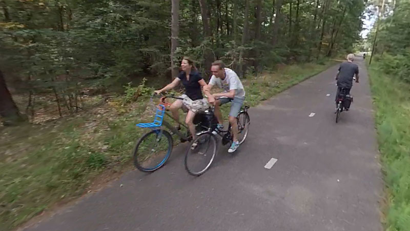
The cycle route on the old railway line from Eindhoven to Belgium was built to reduce the congestion on the car routes between Valkenswaard and Eindhoven (the N69) via Waalre. The old railway line was very straight and that is what you want for cycling, a direct route. The former line was previously used as a place for walking, horseback riding and mountain biking, mainly because it had no hard surface yet. The last regular freight train services had already stopped in 1962, after a detour was built. (That new route has subsequently been abandoned in 1973.) The cycle route on the old railway line is 5 kilometres long and connects very well to existing cycle routes in Valkenswaard, Waalre, and Eindhoven. In the latter it gives a direct access to the Slowlane which I portrayed earlier. Since it is one straight line of smooth asphalt with very little delays (there are only two side streets) it is a very quick and attractive route for people working in Eindhoven who live up to about 15 kilometres from their workplace.


The route runs through a forest and nature was taken into account when the cycleway was constructed. Three amphibian tunnels were built which include guiding fences to lead the creatures to and through these tunnels. Some trees that had grown on the original tracks had to be removed as well as some others to lay the electricity cables for the lighting. To compensate a type of shrubs were planted which help create a natural forest edge, in this case internally; on both sides of the cycle route. The lighting is designed to not hinder wildlife too much. For that reason the lights are switched off after the evening rush hour. The LED lights dim slowly. They are at full capacity from the beginning of darkness until 7pm, from 7pm to 8pm they are at 50% at the entrances so that people can finish their ride. From 8pm the lights are then switched off completely so that animals can spend the night in the dark. The lights switch on again at 6:30 for the morning rush hour, until it is light.


If you look at the cycle route now, it would seem that creating it was a no-brainer. However, that was not clear to everyone so quickly. The planning phase took quite a while and the necessity of this route was questioned by the council of Valkenswaard, one of the municipalities that had to build a large part.


Although that municipality had signed an intention to build the route already in 2004 and from then until 2010 it had become part of the regional cycling policies, the municipal cycle plan and the provincial cooperation plan to improve air quality, the council asked for a second opinion in 2012 because they were no longer sure it was really needed. Mostly because there were already two other cycle routes between Valkenswaard and Eindhoven.

The consultancy asked to investigate the necessity of the route was very clear. The conclusion was that the path would certainly be useful, for the following reasons:
- The cycle route creates a direct and comfortable connection between Valkenswaard and Eindhoven
- The cycle route is centrally located and easily accessible for cycle traffic from the core of Valkenswaard
- The cycle route has an additional value relative to the existing routes. It improves the number of route choices to get to Eindhoven. This stimulates people to take the bicycle.
- The cycle route is better for traffic safety, mainly because there are almost no crossing side streets and there is virtually no motor traffic on the route.
- The cycle route is attractively situated in a forest environment. This makes the route enjoyable, also for recreation.

In the report the council was also reminded that they had already committed to try and reduce car traffic. To reduce congestion it is customary to first take measures that are relatively easy and cheap or at least cost effective. The cycle route on the former railway line was considered by far the easiest intervention to reduce car traffic.

After this report the council did indeed decide to build the route. The construction took place in the summer of 2015 and the path could be used from December 2015. The official and festive opening took place in April 2016. The opening was done by a member of the Executive Council of the Province, two executive council members of the municipalities of Waalre and Valkenwaard and a representative of the local branch of the Cyclists’ Union.

The route is used consistently well. While the cycle counter on the old railway reached 100,000 people in the summer of 2016, in November 2017 it had already counted over 266,000 people. When I saw the counter, late July 2019, I was the 236,805th person to cycle past it.

The cycle route between Valkenswaard, Waalre and Eindhoven is one of the many measures taken in the project Border Corridor N69. In this project 25 parties (municipalities, NGOs protecting nature, organisations protecting the environment, the water authority, traffic organisations, employers’ unions and the national government) are working together with the province to improve accessibility to the villages in the border corridor region as well as their liveability. That this is but a small part of a much larger project with so many actors may explain why I wasn’t able to find any news about the cost for this route.
Ride from Valkenswaard to Waalre in 360 degrees.
Ride from Valkenswaard to Waalre as an ordinary video.
For a different take on this same story see the blog post of Herbert Tiemens.

Hi Mark, Nice post you made about this project! Years ago (somewhere in the 20th century) I adviced the council of Valkenswaard to build a cycle route of the former railway line, happy it is now in use! When I was there the route was just opened. https://herberttiemens.wordpress.com/2015/12/30/exploring-the-cycle-highway-of-eindhoven/#more-747 Good to see the green is full grown now.
One addition: This part of the railway line was abandoned already in 1959, when the council of Eindhoven decided to make a detour over Geldrop, to clear space in Eindhoven. The last train Eindhoven-Valkenswaard via Geldrop was in 1973. The link Valkenswaard-Geldrop was partially converted to a touristic cycling route in the 1990’s. https://nl.wikipedia.org/wiki/Spoorlijn_18_Winterslag_-_Eindhoven
Ah! Thanks for that clarification. I misinterpreted what I had read in my source. I now updated the text. I also added a link to your story, that had completely slipped my mind. (I must have seen it at the time!)