Not too long ago the A2 motorway split the city of Maastricht in two. The internationally important road connection cut off the east of the city from the centre. The space where the road once was is now being redeveloped to be much more a space for people. More than 4 kilometres of green carpet with 2,000 newly planted trees has been constructed in 2017/2018. That became possible after the motorway was buried underground in a 2.3 kilometre long double stacked tunnel. The one billion euro project is still ongoing, it will not be finished before 2026.


A large part of the city of Maastricht is (still) undergoing a complete transformation. The internationally important north-south motorway A2 (Belgian border/Maastricht – Amsterdam) ran right through the city. Constructed in the late 1950s it had become a terrible piece of infrastructure with a big negative influence on the entire eastern part of the city. Not only because that was separated from the rest and especially the centre, but also because of the noise and fumes. Since 2003, four government partners have been working together to create a joint action plan. The Directorate-General for Public Works and Water Management, the municipal council of Maastricht, the provincial government of Limburg and the council of Maastricht’s neighbouring town of Meerssen founded their own project agency called Avenue2. This agency could work quicker and more efficient. Before this partnership, the A2 motorway through Maastricht was primarily seen as a traffic problem; the congestion on the national road leading through the city needed to be improved. The authorities decided that the local economy could not be allowed to suffer from the expected poor accessibility. The location of Maastricht is unique. The border of the city is also – for a large part – the border of the country, so there was no space to lead the road around the city. The 2.3 kilometre long tunnel was therefore a logical and broadly supported solution to this “traffic flow problem”. (Incidently, this Maastricht tunnel is of a similar length as the Central Artery/Tunnel Project in Boston.) Gradually, however, the government bodies, working together in the project agency Avenue2, came to the conclusion that this project was not just a question of infrastructure.

The overall goal of the project was broadened. Instead of tackling a problem this much more became seizing the opportunity to:
- improve the accessibility of Maastricht and create a good traffic flow on and along the A2
- increase road safety and quality of life, in other words improve the liveability in the surrounding areas
- create new urban design possibilities for neighbourhoods alongside the A2 after removing the A2 barrier.
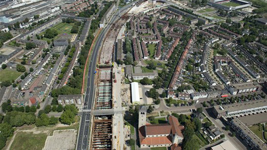
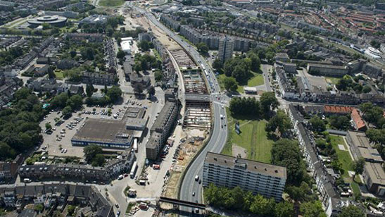
Since you cannot build directly on top of the tunnel the area precisely above it would still have to be a strip of open land. To be able to build the desired new buildings the tunnel was kept as narrow as possible. Instead of 2×3 lanes wide it became 2×2 lanes wide. By creating a tunnel system with two levels a total of 8 lanes could be constructed to achieve the necessary traffic throughput. (Inter)national motor traffic uses the lower level tubes and regional traffic the upper level. Dutch engineers are used to building in soft soil, but Maastricht, far to the south of the rest of the Netherlands, has a very different type of underground. The upper 2 or 3 metres consist of a soft, soil-like clay mixed with sand and peat, but beneath that is a 7 to 8 metre thick layer of a coarse type of gravel with large boulders, followed by a thick layer of limestone (ranging from hard to soft), small caverns and zones of flint (a very hard type of material). In order to build a construction pit for the cut-and-cover tunnel, the engineers called upon the expertise of colleagues in Germany, Belgium, and France. First they built two walls in the soil, in 25 metre deep narrow trenches. Only after these walls were hardened enough the groundwater table could be lowered, steel beams between the sheet pile walls could be installed and the ground between the walls could be removed. What remained was a trench of 2,300 metres long, 30 metres wide, and 17 metres deep in which the stacked tunnel tubes could be constructed, using concrete poured on site. The concrete works started at the beginning of 2012 and ended just before Christmas 2014. The tunnel was opened to traffic in December 2016 and has since won an award for “Underground Space Project of the Year” in 2018.


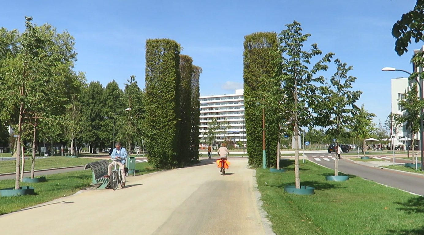
In 2017 and 2018 most of the green carpet on top of the tunnel was constructed. The city specifically didn’t want the focus to be on traffic here, but on space for people. That means there is only one travel lane for motor traffic in each direction. After all, most of the traffic (80%) is now in the tunnels. With the planting of 2,000 trees and the creation of a central part for walking and cycling. This strip of land is now supposed to unite rather than divide. On either side of the new avenue there is ample space for new buildings. A total of 30,000 square metres is planned, including over 1,100 new homes and 6,000 square metres of commercial space.


The total project involves an investment of approximately one billion euros, 850 million of which are being provided by the public sector. The tunnel and the tree lined avenue are now finished. A lot of the outdated old apartment buildings of the late 1950s and early 1960s have been demolished. The development of the new buildings is about to start and will take until 2026.
My video about the A2 motorway tunnel in Maastricht.
A ride on top of the 2.3 km long tunnel in 360 degrees.
Version if you cannot see (or don’t want to watch) a 360 video.
More information in English from the Avenue2 Agency
Opening of the double deck tunnels, audio report in English
CNN video about the project at the start of the dig

Funny. This was considered outrageously expensive here. The costs are right and in line with what such infrastructure costs here.
great post but I think these construction cost figures are somehow outrageous. because why prices in the USA versus those in Europe are so high?
Same question
good drive very good
Brilliant 360-video. Could you tell what camera and mount do you use and how it looks like in mounted state?
These construction cost figures are outrageous. What is wrong with America that drives our prices to be so ridiculously high?
This is explained really well by the people at Prager University
As usual with PragerU, this video is completely false. StrongTowns (a reputable source) has the true reason why American cities can’t fill potholes – they don’t have any money: https://www.strongtowns.org/journal/2017/1/9/the-real-reason-your-city-has-no-money
The great YouTuber “shaun” has some excellent vidoes in the series “How PragerU lies to you”. You might want to check them out: https://www.youtube.com/results?search_query=how+prageru+lies+to+you+shaun
That report doesn’t address the original problem as stated by the OP, namely why prices in the USA versus those in Europe are so high. The Prager University video I linked to does directly address the problem of high prices in the USA.
Since you also state that the video is completely false, please do tell what is false about the statement of it taking five years of review to raise the Bayonne bridge?
Nowhere in the article you linked to are the points of the Prager University video addressed.
As an European I wondered about US infrastructure but I think both points make sense, there was/is never money reserved for maintenance and building/maintenance costs are higher than outside the US.
I think maintenance is way more important than focusing on why infrastructure costs are high, and for sure the simplistic way PragerU tries to derail thins does not help.
There is a problem on costs (not only for infrastructure but also for health care and education) but the solution is not that simple, see https://www.bloomberg.com/opinion/articles/2019-07-26/u-s-infrastructure-construction-costs-pose-threat-to-economy and http://nymag.com/intelligencer/2019/07/why-we-cant-figure-out-why-infrastructure-is-so-expensive.html
How is the US going to solve the maintenance problem?
> please do tell what is false about the statement of it taking five years of review to raise the Bayonne bridge?
Just read https://en.wikipedia.org/wiki/Bayonne_Bridge and yes there were lawsuits but it is far from clear they caused delay and if so much less than 5 years.
For the prices in the USA versus the rest of the world see the graph on https://jabberwocking.com/why-does-it-cost-so-much-to-build-things-in-new-york-city/. the Netherlands and the USA seems to me more or less on par except for New-York.