Think about your living room, chances are you change it completely every 15 to 20 years. Because you need a wider sofa for the expanding family, or because you rightfully think that table has had its best years. Maybe the extra big seat for granddad is sadly not needed anymore. Of course, things can’t always be perfect: you have a budget to consider and it is not so easy to change the walls. Replacing things does give you the opportunity to correct earlier mistakes and to get the things which are more useful now. While you are at it, you can also match the colours and materials better again. Our cities are not so different from our living rooms. Just as families grow and later decrease in size again when the children leave the house, the modal share of the different types of traffic users changes over the years. These shifting modal shares warrant changes to the street design. So you may need some extra space where it was not necessary before, but if you see less and less of a certain type of traffic, its space can be reallocated to other road users.


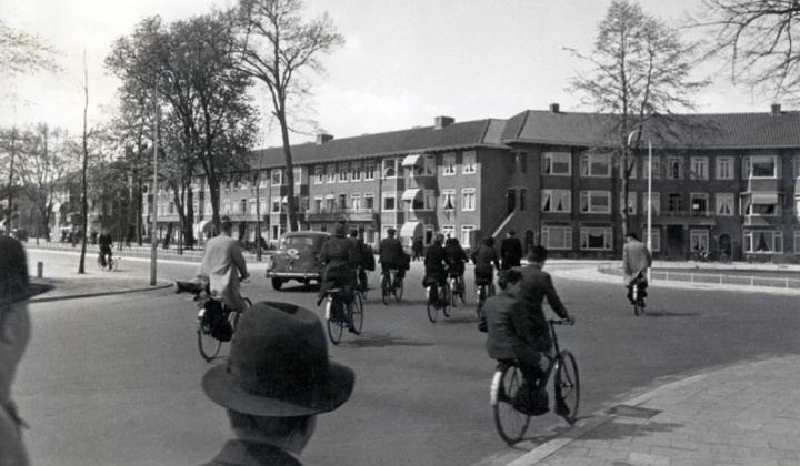
You could see Vondellaan in Utrecht as one such “living room” in a city that changed over the years. It has recently been upgraded to the latest needs of the people using it now. With a lot more space for cycling and a bit less for motor traffic. The latest colours and materials have been used: smooth red asphalt in the case of the cycleways. This wasn’t the first time changes were made to this street. If you look at old photos you can trace what the needs and fashions of days gone by were. A picture of the 1950s shows people cycling using the full width of the roadway. By the 1960s that roadway was no longer safe enough to allow that, with the increased motor traffic volumes. Cycleways had been added for the fewer people cycling at that time, but junctions had not been changed yet. Starting in the 1970s, the patchwork of separated cycleways and other types of cycling infrastructure began to be connected with junctions which were also designed for cycling. That design wasn’t perfect from the start. Pictures from 1980, 1998 and 2015 show how one such T-junction was changed several times. The protected intersection went through some stages, but having learned by trial and error, the design we see now is one that fits the present “family” best. That goes for the entire space. The street design has straight lines, in clear colours and the street is divided to give a dedicated space to every type of user, taking into account how many of these users you will see at this particular location.


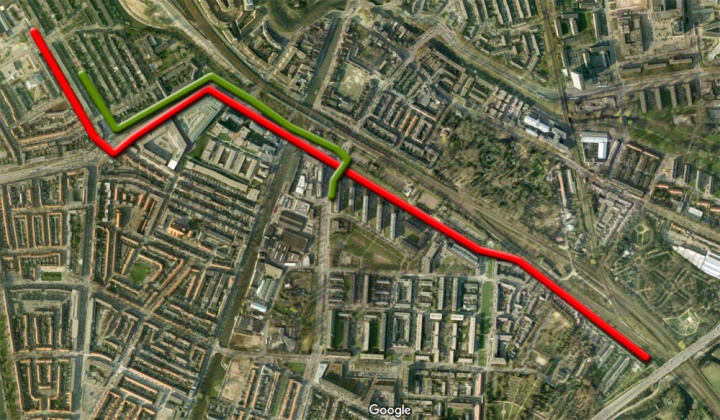
Vondellaan is part of one of the main cycle routes in Utrecht which all have been upgraded recently. I have shown you the route alongside a canal earlier, but I have already filmed other updates, so more posts are planned. The route I show in this post leads from Zuilen past the centre to Lunetten and further to Houten. This particular part of the route follows the railway in the direction of Houten. This railway line was doubled in size recently and even more tracks were added right here for a new railway station, that will be opened at the end of 2016. When you consider parking all kinds of vehicles and access for many people to be able to reach that new railway station, it becomes clear that it requires a lot of changes to the cityscape around it. Since ProRail was already expanding the railway and building the new station, the city of Utrecht commissioned ProRail to also reconstruct Vondellaan and Baden-Powellweg, so all the works could be coordinated better. The streets were completely reconstructed from the foundation up and from façade to façade. The result is a street with a clear route for cycling, with at the same time many types of the current best practice in cycleway and protected junction design. The street can almost serve as a sample book of modern Dutch street design. The videos show just five minutes of cycling both ways and in those five minutes you can see a left turn on a protected intersection, several other protected intersections (both four-arm intersections and T-junctions) and exit constructions (side streets, as well as driveways). The first video even ends on a Fietsstraat (cycle street). There are mono-directional and bi-directional cycleways, but even with all these different types of infrastructure in such a short stretch, the ride still feels as one continuous route. That is what makes modern Dutch cycling infrastructure so good. It is designed as one route, not as a collection of random parts per street. A range of solutions, tailor-made for specific situations, yet one clear, easily recognisable and continuous design.

The ride going south-east (the red line).
The ride going north-west (the green line).
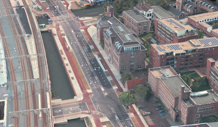
Below, a number of aerial pictures from the 3D option in Apple Maps, to further show the updated infrastructure.


I’ve just seen an article in the press saying cycling is 10% of Germany’s tourism income and approx. 9 billion Euros annually. I wonder what the Netherlands’ figures are?
You do so much to boast cycle tourism, Mark, I think the Dutch Government should sponsor you!!
The first part of the second video looks a bit less than ideal, with some redundant looking traffic lights for cyclists. But perhaps later there will be more motor traffic crossing there.
I noticed some stretches in your first video with more manholes in the surface of the track, like at 4:15. It’s something that’s usually avoided as much as possible, unless it’s very hard to do it otherwise. Anyway, practice in NL is to set them flush with the rest of the surface and while it’s not preferred, you don’t really notice them while cycling along.
The cyclist/pedestrian lights at 0:16 in the second video are only for an access road to a (relocated because of expanded train tracks) sewerage pumping station. Not sure if they stay green 99% of the time, but indeed they seem quite useless.
Then the cyclist lights at 1:50 also seem somewhat redundant to me: I’m pretty sure they are only for the crossing cycling paths as no cars can pass under the railway tracks towards Westerkade.
Oops, it seems that cars can actually cross the cycle path the to enter Westerkade. Not sure I’ve ever seen any though.
Very interesting look at history! I find it interesting in the sixth image (https://bicycledutch.files.wordpress.com/2016/02/vondellaan1980-2015.jpg) the road at the left which appears to no longer cross the railway as it once did, has a much improved design. Gone are the 1960’s era wide, high speed curves. My city is currently planning on improving a similar 1960’s era design, which should improve walkability enormously, some cycling infrastructure is being added, but nothing like this.
Two questions about traffic lights:
Is the green man light normally on long enough for pedestrians to cross in a single stage?
And also, it would be nice if one of these weeks you could borrow a few cameras, set them up looking at each of the traffic signals from all arms, and synchronize the shots, so that we can see who is allowed to go, when. I’ve always wondered how the Dutch manage to have acceptable waiting times despite having separate signals for most movements.
And also a small commentary: I noticed a few flashing white lights next to the signal on the right turning lane. I think it means yield to cyclists and pedestrians as they are approaching and have no separate light phase. I know that the US actually has an equivalent now. Flashing amber arrows, meaning yield, then proceed with your turn in the direction of the arrow. Usually used for left turns, and occasionally used for right turns. Both are still pretty uncommon.
In the Netherlands, turning traffic has to yield to traffic and pedestrians continuing on the same road. This means that a car turning right has to yield to the cycle path and pedestrians crossing the road he’s turning into (provided that these cyclists and pedestrians have green at the same time, of course).
There’s no need for a sign or signal, but are often provided as an additional reminder, since both situations (cyclists/pedestrians having their own green cycle, versus sharing them with turning traffic) will occur within the same city.
Seeing your comment about how granddad might not need that sofa anymore makes me a little sad because I have a feeling like you went through that process and might be implying that you’re not too far away from doing it again. At least as you get older, you get wiser. 2 of my own grandparent’s died a long time ago, 2 still have some life in them.
Seeing the transformations through the years makes me wonder. How quickly did the Dutch manage to get the cycle paths on distributor and through roads and traffic calmed side streets as a figure of percents? This is important to me because I know that such a transformation has to happen fast if cycling is to retain political support. If you build a network too slowly, then people will hate you for causing congestion for a tiny minority of road users, but it is only when there is a safe place to cycle on every street does it become really attractive, or at least safe places on enough streets to have complete journeys.
And something else I’ve been wondering. How do I sort roads with less usual limits like 70 and 60 (km/h) limits into easier to understand groups? I see some through roads in urban areas at 50 km/h and some at 70, and it can be hard to create a distinction. And in the 60 km/h area, i can describe it as rural access roads, but the roads between smaller villages and towns are harder to describe in a simple phrasing. Does anyone have a solution?